February e-Newsletter Community Spotlight with Wouter Knoben
Posted Feb 7, 2025
Wouter Knoben, Senior Research Associate, University of Calgary, Canada, Adjunct Professor, School of Environment and Sustainability, University of Saskatchewan, Canada, Associate Editor of Water Resources Research
CIROH Perceptual Models Project
Understanding hydrologic behavior across large geographical domains is essential to improve our ability to predict water resources and water-related hazards. The hydrologic behavior of a given place can be described by so-called perceptual models. These are text summaries or schematic representations of process knowledge that are typically developed based on field observations for small catchments. Developing perceptual models for continental domains requires a systematic approach to simplify and categorize the complexity of hydrologic behaviour across diverse regions.
Our goal in this project is to divide the continent into a manageable number of hydrologic landscapes: regions that are internally (somewhat) similar while being distinct (in some way) from the landscapes around it. Previous attempts at landscape classification projects have typically been data-based. Our approach complements what large-scale data that can tell us about hydrologic behavior with a community synthesis that taps into the wisdom of hydrologic and critical zone science communities, particularly the first-hand knowledge from those who conduct field studies at catchment and river-reach scales.
An important part of our project was a series of five online workshops co-organized with CUAHSI. These workshops covered five large regions that we defined to distinguish broad differences in first order controls on hydrologic behavior: (1) the east, with its history of land use changes and its dense population; (2) the west, with its extremely varied topography and resulting climates, dense population centers and intensive irrigated agriculture; (3) the north, with its vast cold areas vulnerable to climate change; (4) the central plains and prairies, with its extensive agriculture; and, finally, (5) the tropical islands, with their sharp contrasts in hydroclimatic conditions over very short distances. Each of these workshops featured two to four keynote speakers with experience in hydrological fieldwork and expertise in defining perceptual models in the workshop’s focus region. All workshop participants contributed to the synthesis discussion.
The workshops highlighted the large physiographic gradients within each of the five regions. The outcomes from the workshops was sub-dividing the broader regions into multiple hydrologic landscapes, as well as summarizing the dominant hydrologic processes in each landscape. This synthesis work has continued after the workshops in various meetings where we attempted to outline key hydrologic features at both the region and the landscape levels, i.e., what is common across the larger region, and what is unique to each landscape. Our team presented a prototype map of hydrologic landscapes at the AGU Fall Meeting 2024 and held two further community input events during AGU. We are now working on refining the map of hydrologic landscapes and defining perceptual models of hydrologic processes for each of the defined landscapes.

Photo 1: Workshop dinner during the AGU Annual Meeting in December
The goal of this project is to provide a synthesis of dominant hydrologic processes across a very large geographical domain. Interacting with members of the community has been a terrific way to do this because it lets us combine the insights we get from data (for example, digital elevation models or satellite observations of land cover) with the insights from field scientists working in a given region for a long time. Merging the analysis of big datasets with field-based insights has led to an initial map of hydrologic landscapes across North America – the number of landscapes is small enough such that it is still possible to appreciate their key differences, while at the same time acknowledging the extreme variety of hydrologic conditions one can find across the continent.
These insights are already proving to be helpful to create models for specific regions across the continent that closely resemble the real-world processes. The work is also feeding into further work that does not have hydrology as its main goal, such as ecology, or water resource allocation. It has been very satisfying to collaborate with so many members of the community to make this project take shape.
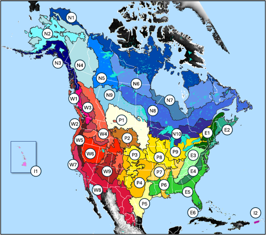
Figure 1: Preliminary map of hydrologic landscapes (work in progress)