
Community Data Spotlight - MODIS/VIIRS Global Water Reservoir Product
Posted Oct 9, 2024
Community Data Spotlight - MODIS/VIIRS Global Water Reservoir Product
- Dr. Huilin Gao, Professor
- Dr. Deep Shah, Postdoctoral Researcher
- Dr. Shuai Zhang, Assistant Research Scientist
Zachry Department of Civil and Environmental Engineering, Texas A&M University
Access to freshwater is one of the key challenges facing our global community. Reservoirs play a crucial role in safeguarding sustainable and reliable water supplies, as they hold a substantial portion of the world's freshwater reserves. Their importance cannot be overstated when it comes to ensuring long-term water security.
One of the significant advantages of remote sensing with regard to global water monitoring is its ability to fill data gaps. Not all nations consistently track their water levels, and, even when they do, the information is not always readily available or openly shared. Satellite based remote sensing offers a solution by providing accurate and timely water monitoring data, which is essential for effective water resource management and informed policy-making.
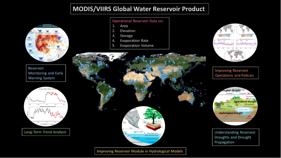
Our group—including myself, Huilin Gao, postdoc Deep Shah, and research scientist Shuai Zhang—collaborated with NASA on a recently published dataset in Nature Scientific Data. This research centers on the development of NASA’s Global Water Reservoir (GWR) product using observations from the Visible Infrared Imaging Radiometer Suite (VIIRS), a sensor aboard the Suomi National Polar-orbiting Partnership (NPP), NOAA-20, and NOAA-21 satellites. Future satellites with VIIRS onboard are further planned through 2031. The primary goal of the study was to ensure the continuity of data from the Moderate Resolution Imaging Spectroradiometer (MODIS) GWR product, establishing VIIRS as MODIS's successor for monitoring global reservoirs.
Satellites carrying sensors like MODIS and VIIRS are typically designed to serve multiple purposes, with planned missions lasting 5-10 years (although many outlive these expectations). One of the critical functions of MODIS (onboard the Terra and Aqua satellites) has been to monitor water reservoirs globally—a role it has successfully played for 24 years. The VIIRS sensor series, first launched in 2011 aboard the Suomi NPP satellite, is expected to carry on the continuity of this task.
Given the differences in the technologies between MODIS and VIIRS, ensuring seamless data continuity is essential—not only for verifying new data, but also for preserving long-term historical records. We aim to use the overlapping period between MODIS and VIIRS to confirm whether VIIRS can fully take over once MODIS is decommissioned. To achieve this, MODIS data from 2000 to 2012 and VIIRS data from 2012 to 2021 were merged. These combined datasets were then compared against MODIS data spanning 2000-2021 to ensure consistent trends.
Historically, satellite measurements of lakes and reservoirs focused mainly on size and water volume. However, this new study introduces the measurement of water loss through evaporation, providing a more comprehensive view of water resource dynamics.
Over the years, our research team has engaged in expanding the capabilities of monitoring reservoirs from space, continuously adding more locations and variables to refine our studies. Our latest work presents an open-access, operational dataset covering area, elevation, storage, evaporation rate, and evaporation volume at 8-day and monthly temporal resolutions for 164 large reservoirs worldwide. This includes data from 151 artificial reservoirs and 13 regulated natural lakes, offering valuable insights for environmental research and water management. We are planning to expand this operational product to 2700+ reservoirs and natural lakes.
For more information regarding our data, you can visit the operational website and the product overview page.